WY DOT Network - other tables for WY include: All Networks, AGRIMET, CWOP/APRS, COOP, HADS, METAR, RAWS, see our homepage.
|
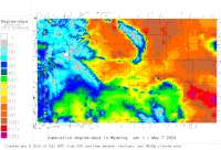
Also try the full-featured calculator/DD model | |
Disease Alert Movies: fireblight: 2010 2011 2012 2013 | ||
|
| |||||||||||||||||||||||||||
|
Wyoming USA Weather Data, Plant Disease Risk and Degree-Day Models WY DOT Network - other tables for WY include: All Networks, AGRIMET, CWOP/APRS, COOP, HADS, METAR, RAWS, see our homepage. | |||||||||||||||||||||||||||
| |||||||||||||||||||||||||||
| # | Location linked to hourly weather, plant disease models and forecasts using "Mypest Page" |
County |
Re- cent data QA |
Fore- cast based virt data |
Nearby station based virt data |
Station code, links to NWS recent weather |
Links to NWS fore- casts |
Net- work Elev. (ft) |
Lat./ Long. (Dec. Deg.) |
Max-min temperature data and degree-days (click radio button to calc.) |
10 yr avgs |
30 yr avgs |
nmme fcast |
cfs fcast |
||||||||||||
|---|---|---|---|---|---|---|---|---|---|---|---|---|---|---|---|---|---|---|---|---|---|---|---|---|---|---|
| 1 | Arlington E by Arlingt | Carbon Count |
|
na na |
na na |
|
|
7647 | 41.58722 -106.17917 |
2021
|
2020
|
2019
|
2018
|
2017
|
AVG | AVG | nmme | |||||||||
| 2 | Arlington I80 W of Lar | Carbon |
|
na na |
na na |
|
|
7763 | 41.59833 -106.21361 |
2021
|
2020
|
2019
|
2018
|
2017
|
AVG | AVG | nmme | |||||||||
| 3 | Bear Creek | Laramie Coun |
|
na na |
na na |
|
|
5820 | 41.64806 -104.84694 |
2021
|
2020
|
2019
|
2018
|
2017
|
AVG | AVG | nmme | |||||||||
| 4 | Beaver Rim US 287WYO 7 | Fremont |
|
na na |
na na |
|
|
6699 | 42.58639 -108.28722 |
2021
|
2020
|
2019
|
2018
|
2017
|
AVG | AVG | nmme | |||||||||
| 5 | Belle Fourche US 59 S | Campbell |
|
na na |
na na |
|
|
4698 | 43.93222 -105.44556 |
2021
|
2020
|
2019
|
2018
|
2017
|
AVG | AVG | nmme | |||||||||
| 6 | Beulah Interchange by | Crook County |
|
na na |
na na |
|
|
3514 | 44.54278 -104.08083 |
2021
|
2020
|
2019
|
2018
|
2017
|
AVG | AVG | nmme | |||||||||
| 7 | Big Horn County Line | Big Horn Cou |
|
na na |
na na |
|
|
8038 | 44.16750 -107.24833 |
2021
|
2020
|
2019
|
2018
|
2017
|
AVG | AVG | nmme | |||||||||
| 8 | Bordeaux I25 S of Whea | Platte |
|
na na |
na na |
|
|
4698 | 41.92972 -104.93972 |
2021
|
2020
|
2019
|
2018
|
2017
|
AVG | AVG | nmme | |||||||||
| 9 | Buford East | Albany Count |
|
na na |
na na |
|
|
7769 | 41.11778 -105.28056 |
2021
|
2020
|
2019
|
2018
|
2017
|
AVG | AVG | nmme | |||||||||
| 10 | Cheyenne East | Laramie Coun |
|
na na |
na na |
|
|
5903 | 41.15917 -104.60583 |
2021
|
2020
|
2019
|
2018
|
2017
|
AVG | AVG | nmme | |||||||||
| 11 | Chief JosephO 296 N | Park |
|
na na |
na na |
|
|
8297 | 44.74444 -109.38194 |
2021
|
2020
|
2019
|
2018
|
2017
|
AVG | AVG | nmme | |||||||||
| 12 | Co Road 402 by Elk Mtn | Carbon Count |
|
na na |
na na |
|
|
7363 | 41.66944 -106.37083 |
2021
|
2020
|
2019
|
2018
|
2017
|
AVG | AVG | nmme | |||||||||
| 13 | Coal Road | Uinta County |
|
na na |
na na |
|
|
7349 | 41.29639 -110.68500 |
2021
|
2020
|
2019
|
2018
|
2017
|
AVG | AVG | nmme | |||||||||
| 14 | Continental Div I80 W | Carbon |
|
na na |
na na |
|
|
7037 | 41.71500 -107.78389 |
2021
|
2020
|
2019
|
2018
|
2017
|
AVG | AVG | nmme | |||||||||
| 15 | Cooper Cove by Arlingt | Carbon Count |
|
na na |
na na |
|
|
7530 | 41.54861 -106.08889 |
2021
|
2020
|
2019
|
2018
|
2017
|
AVG | AVG | nmme | |||||||||
| 16 | Dana Ridge | Carbon Count |
|
na na |
na na |
|
|
7320 | 41.73333 -106.64806 |
2021
|
2020
|
2019
|
2018
|
2017
|
AVG | AVG | nmme | |||||||||
| 17 | Dead Horse I90 tween B | Johnson |
|
na na |
na na |
|
|
4098 | 44.21917 -106.10389 |
2021
|
2020
|
2019
|
2018
|
2017
|
AVG | AVG | nmme | |||||||||
| 18 | Deer Cr I25 E of Caspe | Converse |
|
na na |
na na |
|
|
5098 | 42.83667 -105.86083 |
2021
|
2020
|
2019
|
2018
|
2017
|
AVG | AVG | nmme | |||||||||
| 19 | Elk Mountain | Carbon Count |
|
na na |
na na |
|
|
7384 | 41.72000 -106.45000 |
2021
|
2020
|
2019
|
2018
|
2017
|
AVG | AVG | nmme | |||||||||
| 20 | Evanston | Uinta County |
|
na na |
na na |
|
|
6755 | 41.26083 -110.97583 |
2021
|
2020
|
2019
|
2018
|
2017
|
AVG | AVG | nmme | |||||||||
| 21 | Farson | Sweetwater C |
|
na na |
na na |
|
|
6594 | 42.10861 -109.44917 |
2021
|
2020
|
2019
|
2018
|
2017
|
AVG | AVG | nmme | |||||||||
| 22 | First Div I80 E of Eva | Uinta |
|
na na |
na na |
|
|
7579 | 41.29556 -110.77278 |
2021
|
2020
|
2019
|
2018
|
2017
|
AVG | AVG | nmme | |||||||||
| 23 | Foote Cr by Arlington | Carbon Count |
|
na na |
na na |
|
|
7503 | 41.62139 -106.24083 |
2021
|
2020
|
2019
|
2018
|
2017
|
AVG | AVG | nmme | |||||||||
| 24 | French | Uinta County |
|
na na |
na na |
|
|
7375 | 41.29750 -110.55778 |
2021
|
2020
|
2019
|
2018
|
2017
|
AVG | AVG | nmme | |||||||||
| 25 | Gun Barrel US 85 NE of | Laramie |
|
na na |
na na |
|
|
5597 | 41.43889 -104.34000 |
2021
|
2020
|
2019
|
2018
|
2017
|
AVG | AVG | nmme | |||||||||
| 26 | Halleck Ridge by Elk M | Carbon Count |
|
na na |
na na |
|
|
7206 | 41.75306 -106.51139 |
2021
|
2020
|
2019
|
2018
|
2017
|
AVG | AVG | nmme | |||||||||
| 27 | Herrick Ln by Laramie | Albany Count |
|
na na |
na na |
|
|
7157 | 41.39500 -105.82389 |
2021
|
2020
|
2019
|
2018
|
2017
|
AVG | AVG | nmme | |||||||||
| 28 | Hiland US 2026 between | Natrona |
|
na na |
na na |
|
|
6099 | 43.09278 -107.32306 |
2021
|
2020
|
2019
|
2018
|
2017
|
AVG | AVG | nmme | |||||||||
| 29 | Hynds Lodge Rd | Laramie Coun |
|
na na |
na na |
|
|
7603 | 41.19056 -105.25500 |
2021
|
2020
|
2019
|
2018
|
2017
|
AVG | AVG | nmme | |||||||||
| 30 | I25 Hat Six | Natrona Coun |
|
na na |
na na |
|
|
5157 | 42.83917 -106.20167 |
2021
|
nmme | |||||||||||||||
| 31 | I25 Div I25 N of Kayce | Johnson |
|
na na |
na na |
|
|
5059 | 43.94028 -106.64639 |
2021
|
2020
|
2019
|
2018
|
2017
|
AVG | AVG | nmme | |||||||||
| 32 | I25US87 Smokey Gap | Natrona Coun |
|
na na |
na na |
|
|
5161 | 43.42806 -106.38583 |
2021
|
nmme | |||||||||||||||
| 33 | I25US26US87PlatteConv | Converse Cou |
|
na na |
na na |
|
|
4711 | 42.59917 -105.10250 |
2021
|
nmme | |||||||||||||||
| 34 | I25US87F St Hill | Natrona Coun |
|
na na |
na na |
|
|
5312 | 42.86639 -106.34472 |
2021
|
nmme | |||||||||||||||
| 35 | I25US87Tisdale Div | Johnson Coun |
|
na na |
na na |
|
|
4990 | 43.54444 -106.48306 |
2021
|
nmme | |||||||||||||||
| 36 | I80US189Bear Rvr Dr | Uinta County |
|
na na |
na na |
|
|
6834 | 41.26667 -110.92556 |
2021
|
nmme | |||||||||||||||
| 37 | I80US189Evanston POE | Uinta County |
|
na na |
na na |
|
|
6762 | 41.24722 -111.04556 |
2021
|
nmme | |||||||||||||||
| 38 | I90 Pompey Creek | Sheridan Cou |
|
na na |
na na |
|
|
4429 | 44.64333 -106.86389 |
2021
|
nmme | |||||||||||||||
| 39 | Indian Creek Rd | Johnson Coun |
|
na na |
na na |
|
|
4367 | 44.19556 -106.25500 |
2021
|
2020
|
2019
|
2018
|
2017
|
AVG | AVG | nmme | |||||||||
| 40 | Inyan Kara I90 W of Su | Crook |
|
na na |
na na |
|
|
4357 | 44.29306 -104.62944 |
2021
|
2020
|
2019
|
2018
|
2017
|
AVG | AVG | nmme | |||||||||
| 41 | Leroy | Uinta County |
|
na na |
na na |
|
|
6886 | 41.29889 -110.63889 |
2021
|
2020
|
2019
|
2018
|
2017
|
AVG | AVG | nmme | |||||||||
| 42 | Lone Tree | Albany Count |
|
na na |
na na |
|
|
8005 | 41.12806 -105.33917 |
2021
|
2020
|
2019
|
2018
|
2017
|
AVG | AVG | nmme | |||||||||
| 43 | Meeteetse US 120 N of | Park |
|
na na |
na na |
|
|
5958 | 44.27083 -108.87306 |
2021
|
2020
|
2019
|
2018
|
2017
|
AVG | AVG | nmme | |||||||||
| 44 | Mile Marker 108 | Campbell Cou |
|
na na |
na na |
|
|
4788 | 44.21750 -105.81250 |
2021
|
2020
|
2019
|
2018
|
2017
|
AVG | AVG | nmme | |||||||||
| 45 | Mile Marker 2491 | Carbon Count |
|
na na |
na na |
|
|
7139 | 41.74139 -106.56750 |
2021
|
2020
|
2019
|
2018
|
2017
|
AVG | AVG | nmme | |||||||||
| 46 | Montana Line by Ranche | Big Horn Cou |
|
na na |
na na |
|
|
4320 | 44.99972 -107.29778 |
2021
|
2020
|
2019
|
2018
|
2017
|
AVG | AVG | nmme | |||||||||
| 47 | MP 3530 | Laramie Coun |
|
na na |
na na |
|
|
6532 | 41.10944 -104.97472 |
2021
|
2020
|
2019
|
2018
|
2017
|
AVG | AVG | nmme | |||||||||
| 48 | Natrona | Natrona Coun |
|
na na |
na na |
|
|
5589 | 43.02917 -106.80083 |
2021
|
2020
|
2019
|
2018
|
2017
|
AVG | AVG | nmme | |||||||||
| 49 | Nugget Canyon by Kemme | Lincoln Coun |
|
na na |
na na |
|
|
6718 | 41.82028 -110.80806 |
2021
|
2020
|
2019
|
2018
|
2017
|
AVG | AVG | nmme | |||||||||
| 50 | Otto | Laramie Coun |
|
na na |
na na |
|
|
6981 | 41.10028 -105.07417 |
2021
|
2020
|
2019
|
2018
|
2017
|
AVG | AVG | nmme | |||||||||
| 51 | Pathfinder Hill US 220 | Natrona |
|
na na |
na na |
|
|
6319 | 42.56000 -106.85278 |
2021
|
2020
|
2019
|
2018
|
2017
|
AVG | AVG | nmme | |||||||||
| 52 | Peru Hill I80 at Green | Sweetwater |
|
na na |
na na |
|
|
6440 | 41.55000 -109.60000 |
2021
|
2020
|
2019
|
2018
|
2017
|
AVG | AVG | nmme | |||||||||
| 53 | Peru Hill I80 W of Gre | Sweetwater |
|
na na |
na na |
|
|
6427 | 41.53278 -109.46194 |
2021
|
2020
|
2019
|
2018
|
2017
|
AVG | AVG | nmme | |||||||||
| 54 | Pine Tree Junction | Campbell Cou |
|
na na |
na na |
|
|
5376 | 43.61722 -105.78583 |
2021
|
2020
|
2019
|
2018
|
2017
|
AVG | AVG | nmme | |||||||||
| 55 | Pt of Rocks by Rock Sp | Sweetwater C |
|
na na |
na na |
|
|
6747 | 41.68222 -108.80139 |
2021
|
2020
|
2019
|
2018
|
2017
|
AVG | AVG | nmme | |||||||||
| 56 | Pumpkin Vine US 287 S | Albany |
|
na na |
na na |
|
|
7999 | 41.07444 -105.46889 |
2021
|
2020
|
2019
|
2018
|
2017
|
AVG | AVG | nmme | |||||||||
| 57 | Quealy Dome by Laramie | Albany Count |
|
na na |
na na |
|
|
7488 | 41.44389 -105.96111 |
2021
|
2020
|
2019
|
2018
|
2017
|
AVG | AVG | nmme | |||||||||
| 58 | Red CanyonO 28 twee | Fremont |
|
na na |
na na |
|
|
6762 | 42.61500 -108.60611 |
2021
|
2020
|
2019
|
2018
|
2017
|
AVG | AVG | nmme | |||||||||
| 59 | Remount by Cheyenne | Laramie Coun |
|
na na |
na na |
|
|
7583 | 41.10000 -105.20972 |
2021
|
2020
|
2019
|
2018
|
2017
|
AVG | AVG | nmme | |||||||||
| 60 | Rock Sprs W by Rock Sp | Sweetwater C |
|
na na |
na na |
|
|
6903 | 41.55000 -109.32972 |
2021
|
2020
|
2019
|
2018
|
2017
|
AVG | AVG | nmme | |||||||||
| 61 | S PassO 28 @ Pass | Fremont |
|
na na |
na na |
|
|
8202 | 42.47639 -108.84528 |
2021
|
2020
|
2019
|
2018
|
2017
|
AVG | AVG | nmme | |||||||||
| 62 | Sage Jct US 30 W of Ke | Lincoln |
|
na na |
na na |
|
|
7779 | 41.82278 -110.90306 |
2021
|
2020
|
2019
|
2018
|
2017
|
AVG | AVG | nmme | |||||||||
| 63 | Shirley Rim | Carbon Count |
|
na na |
na na |
|
|
7220 | 42.37583 -106.23750 |
2021
|
2020
|
2019
|
2018
|
2017
|
AVG | AVG | nmme | |||||||||
| 64 | Shute CrO 372 Grn | Sweetwater |
|
na na |
na na |
|
|
6752 | 41.93056 -109.96806 |
2021
|
2020
|
2019
|
2018
|
2017
|
AVG | AVG | nmme | |||||||||
| 65 | Sinclair | Carbon Count |
|
na na |
na na |
|
|
6566 | 41.77000 -107.09000 |
2021
|
2020
|
2019
|
2018
|
2017
|
AVG | AVG | nmme | |||||||||
| 66 | Skyline 230O 230 SE | Carbon |
|
na na |
na na |
|
|
8097 | 41.13167 -106.56000 |
2021
|
2020
|
2019
|
2018
|
2017
|
AVG | AVG | nmme | |||||||||
| 67 | Strouss Hill | Albany Count |
|
na na |
na na |
|
|
7753 | 41.49611 -106.04583 |
2021
|
2020
|
2019
|
2018
|
2017
|
AVG | AVG | nmme | |||||||||
| 68 | Summit East by Laramie | Albany Count |
|
na na |
na na |
|
|
8577 | 41.20056 -105.43444 |
2021
|
2020
|
2019
|
2018
|
2017
|
AVG | AVG | nmme | |||||||||
| 69 | Superior by Rock Sprs | Sweetwater C |
|
na na |
na na |
|
|
6706 | 41.69194 -108.90028 |
2021
|
2020
|
2019
|
2018
|
2017
|
AVG | AVG | nmme | |||||||||
| 70 | Teton PassO 22 W of | Teton |
|
na na |
na na |
|
|
8428 | 43.49694 -110.95528 |
2021
|
2020
|
2019
|
2018
|
2017
|
AVG | AVG | nmme | |||||||||
| 71 | Tipton | Sweetwater C |
|
na na |
na na |
|
|
6907 | 41.63000 -108.29639 |
2021
|
2020
|
2019
|
2018
|
2017
|
AVG | AVG | nmme | |||||||||
| 72 | Twenty Mile Hill I25 N | Natrona |
|
na na |
na na |
|
|
5758 | 43.12306 -106.33667 |
2021
|
2020
|
2019
|
2018
|
2017
|
AVG | AVG | nmme | |||||||||
| 73 | US14 Granite Pass | Big Horn Cou |
|
na na |
na na |
|
|
8953 | 44.65250 -107.49667 |
2021
|
nmme | |||||||||||||||
| 74 | US20 Van Tassell | Niobrara Cou |
|
na na |
na na |
|
|
4829 | 42.66917 -104.15750 |
2021
|
nmme | |||||||||||||||
| 75 | US85 Four Corners | Weston Count |
|
na na |
na na |
|
|
5873 | 44.08056 -104.13583 |
2021
|
nmme | |||||||||||||||
| 76 | Vedauwoo I80 between C | Albany |
|
na na |
na na |
|
|
8399 | 41.15667 -105.40306 |
2021
|
2020
|
2019
|
2018
|
2017
|
AVG | AVG | nmme | |||||||||
| 77 | Wagonhound by Arlingto | Carbon Count |
|
na na |
na na |
|
|
7548 | 41.63944 -106.29306 |
2021
|
2020
|
2019
|
2018
|
2017
|
AVG | AVG | nmme | |||||||||
| 78 | Walcott Junction | Carbon Count |
|
na na |
na na |
|
|
6672 | 41.74139 -106.84167 |
2021
|
2020
|
2019
|
2018
|
2017
|
AVG | AVG | nmme | |||||||||
| 79 | Whitaker I25 N of Chey | Laramie |
|
na na |
na na |
|
|
6201 | 41.41889 -104.87333 |
2021
|
2020
|
2019
|
2018
|
2017
|
AVG | AVG | nmme | |||||||||
| 80 | Wildcat Trail | Laramie Coun |
|
na na |
na na |
|
|
7312 | 41.19389 -105.20000 |
2021
|
2020
|
2019
|
2018
|
2017
|
AVG | AVG | nmme | |||||||||
| 81 | Wind River Lake | Teton County |
|
na na |
na na |
|
|
9576 | 43.74833 -110.06028 |
2021
|
2020
|
2019
|
2018
|
2017
|
AVG | AVG | nmme | |||||||||
| 82 | WYO 258 | Natrona Coun |
|
na na |
na na |
|
|
5463 | 42.80611 -106.30806 |
2021
|
2020
|
2019
|
2018
|
2017
|
AVG | AVG | nmme | |||||||||
| 83 | Wyo Hill I25 S of Chey | Laramie |
|
na na |
na na |
|
|
6430 | 41.04750 -104.89000 |
2021
|
2020
|
2019
|
2018
|
2017
|
AVG | AVG | nmme | |||||||||
[USPEST.ORG/WEA Home]
[Intro]
[US DD Mapmaker]
[Main Table Index]
[Links]


|