METAR Network - other tables for WA include: All Networks, AGRIMET, CWOP/APRS, COOP, HADS, RAWS, WA_DOT, AGWEATHERNET, see our homepage.
|
Also try the full-featured calculator/DD model | |
|
| |||||||||||||||||||||||||
|
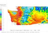
Washington USA Weather Data, Plant Disease Risk and Degree-Day Models METAR Network - other tables for WA include: All Networks, AGRIMET, CWOP/APRS, COOP, HADS, RAWS, WA_DOT, AGWEATHERNET, see our homepage. | |||||||||||||||||||||||||
| |||||||||||||||||||||||||
| # | Location linked to hourly weather, plant disease models and forecasts using "Mypest Page" removed due to excessive bot activity |
County |
Re- cent data QA |
Fore- cast based virt data |
Nearby station based virt data |
Station code, links to NWS recent weather |
Links to NWS fore- casts |
Net- work Elev. (ft) |
Lat./ Long. (Dec. Deg.) |
Max-min temperature data and degree-days (click radio button to calc.) |
10 yr avgs |
30 yr avgs |
nmme fcast |
cfs fcast |
||||||||||
|---|---|---|---|---|---|---|---|---|---|---|---|---|---|---|---|---|---|---|---|---|---|---|---|---|
| 1 | KelsoLongview Airport | Cowlitz |
|
na na |
na na |
|
|
20 | 46.11667 -122.90000 |
2021
|
2020
|
2019
|
2018
|
2017
|
2016
|
AVG | AVG | nmme | cfs | |||||
| 2 | Arlington Municipal | Snohomish |
|
na na |
na na |
|
|
138 | 48.16667 -122.16667 |
2021
|
2020
|
2019
|
2018
|
2017
|
2016
|
AVG | AVG | nmme | cfs | |||||
| 3 | Bellingham Int Apt | Whatcom |
|
na na |
na na |
|
|
148 | 48.79889 -122.54056 |
2021
|
2020
|
2019
|
2018
|
2017
|
2016
|
AVG | AVG | nmme | cfs | |||||
| 4 | Bremerton Nat Apt | Kitsap |
|
na na |
na na |
|
|
440 | 47.50000 -122.75000 |
2021
|
2020
|
2019
|
2018
|
2017
|
2016
|
AVG | AVG | nmme | cfs | |||||
| 5 | BurlingtonMount Vernon | Skagit |
|
na na |
na na |
|
|
144 | 48.47056 -122.42056 |
2021
|
2020
|
2019
|
2018
|
2017
|
2016
|
AVG | AVG | nmme | cfs | |||||
| 6 | ChehalisCentralia Apt | Lewis |
|
na na |
na na |
|
|
177 | 46.67694 -122.98250 |
2021
|
2020
|
2019
|
2018
|
2017
|
2016
|
AVG | AVG | nmme | cfs | |||||
| 7 | Colville Muni Apt | Stevens Coun |
|
na na |
na na |
|
|
1888 | 48.54417 -117.88333 |
2021
|
nmme | cfs | ||||||||||||
| 8 | Coupeville Outlying La | Island Count |
|
na na |
na na |
|
|
197 | 48.19056 -122.63056 | nmme | ||||||||||||||
| 9 | Deer Park Airport | Spokane |
|
na na |
na na |
|
|
2205 | 47.97417 -117.42806 |
2021
|
2020
|
2019
|
2018
|
2017
|
2016
|
AVG | AVG | nmme | cfs | |||||
| 10 | Ellensburg Bowers Fld | Kittitas |
|
na na |
na na |
|
|
1745 | 47.03361 -120.53111 |
2021
|
2020
|
2019
|
2018
|
2017
|
2016
|
AVG | AVG | nmme | cfs | |||||
| 11 | Ephrata Muni Apt | Douglas |
|
na na |
na na |
|
|
1276 | 47.30722 -119.51556 |
2021
|
2020
|
2019
|
2018
|
2017
|
2016
|
AVG | AVG | nmme | cfs | |||||
| 12 | Esound Orcas Is Apt | San Juan |
|
na na |
na na |
|
|
30 | 48.70806 -122.91028 |
2021
|
2020
|
2019
|
2018
|
2017
|
2016
|
AVG | AVG | nmme | cfs | |||||
| 13 | Everett Snohomish Co A | Snohomish |
|
na na |
na na |
|
|
604 | 47.92306 -122.28222 |
2021
|
2020
|
2019
|
2018
|
2017
|
2016
|
AVG | AVG | nmme | cfs | |||||
| 14 | Fairchild AFB | Spokane |
|
na na |
na na |
|
|
2461 | 47.61667 -117.65000 |
2021
|
2020
|
2019
|
2018
|
2017
|
2016
|
AVG | AVG | nmme | cfs | |||||
| 15 | Friday Harbor Airport | San Juan |
|
na na |
na na |
|
|
108 | 48.52028 -123.02528 |
2021
|
2020
|
2019
|
2018
|
2017
|
2016
|
AVG | AVG | nmme | cfs | |||||
| 16 | Ft Lewis Gray U S Ar | Pierce |
|
na na |
na na |
|
|
302 | 47.11667 -122.55000 |
2021
|
2020
|
2019
|
2018
|
2017
|
2016
|
AVG | AVG | nmme | cfs | |||||
| 17 | Grand Coulee Dam Apt | Douglas Coun |
|
na na |
na na |
|
|
1593 | 47.92194 -119.08278 | nmme | ||||||||||||||
| 18 | Hoquiam Bowerman Apt | Grays Harbor |
|
na na |
na na |
|
|
13 | 46.97083 -123.92000 |
2021
|
2020
|
2019
|
2018
|
2017
|
2016
|
AVG | AVG | nmme | cfs | |||||
| 19 | Methow Valley | Okanogan Cou |
|
na na |
na na |
|
|
1706 | 48.42472 -120.14583 |
2021
|
nmme | cfs | ||||||||||||
| 20 | Moses Lk Grant Co Apt | Grant |
|
na na |
na na |
|
|
1184 | 47.19306 -119.31306 |
2021
|
2020
|
2019
|
2018
|
2017
|
2016
|
AVG | AVG | nmme | cfs | |||||
| 21 | Olympia Airport | Thurston |
|
na na |
na na |
|
|
203 | 46.97306 -122.90306 |
2021
|
2020
|
2019
|
2018
|
2017
|
2016
|
AVG | AVG | nmme | cfs | |||||
| 22 | Omak Airport | Okanogan |
|
na na |
na na |
|
|
1302 | 48.46417 -119.51806 |
2021
|
2020
|
2019
|
2018
|
2017
|
2016
|
AVG | AVG | nmme | cfs | |||||
| 23 | Pasco TriCities Apt | Franklin |
|
na na |
na na |
|
|
407 | 46.26944 -119.11667 |
2021
|
2020
|
2019
|
2018
|
2017
|
2016
|
AVG | AVG | nmme | cfs | |||||
| 24 | Pierce CoThun Fld | King |
|
na na |
na na |
|
|
538 | 47.10389 -122.28694 |
2021
|
2020
|
2019
|
2018
|
2017
|
2016
|
AVG | AVG | nmme | cfs | |||||
| 25 | Prosser | Benton Count |
|
na na |
na na |
|
|
697 | 46.21333 -119.79139 |
2021
|
2020
|
2019
|
2018
|
AVG | AVG | nmme | cfs | |||||||
| 26 | Pt Angeles Coast Guard | Clallam Coun |
|
na na |
na na |
|
|
16 | 48.13306 -123.40000 | nmme | ||||||||||||||
| 27 | Pt Angeles William R | Clallam |
|
na na |
na na |
|
|
285 | 48.12194 -123.50528 |
2021
|
2020
|
2019
|
2018
|
2017
|
2016
|
AVG | AVG | nmme | cfs | |||||
| 28 | Pt Townsend Jefferson | Jefferson Co |
|
na na |
na na |
|
|
105 | 48.05500 -122.81139 |
2021
|
2020
|
2019
|
2018
|
2017
|
2016
|
AVG | AVG | nmme | cfs | |||||
| 29 | Pullman Moscow Reg Apt | Whitman |
|
na na |
na na |
|
|
2556 | 46.74389 -117.10944 |
2021
|
2020
|
2019
|
2018
|
2017
|
2016
|
AVG | AVG | nmme | cfs | |||||
| 30 | Quillayute St Apt | Clallam |
|
na na |
na na |
|
|
194 | 47.93750 -124.55500 |
2021
|
2020
|
2019
|
2018
|
2017
|
2016
|
AVG | AVG | nmme | cfs | |||||
| 31 | Renton Muni Apt | King |
|
na na |
na na |
|
|
26 | 47.49417 -122.21278 |
2021
|
2020
|
2019
|
2018
|
2017
|
2016
|
AVG | AVG | nmme | cfs | |||||
| 32 | Richland AP AWOS | Franklin |
|
na na |
na na |
|
|
394 | 46.30556 -119.30417 |
2021
|
2020
|
2019
|
2018
|
AVG | AVG | nmme | cfs | |||||||
| 33 | Seattle Boeing Field | King |
|
na na |
na na |
|
|
16 | 47.54556 -122.31333 |
2021
|
2020
|
2019
|
2018
|
2017
|
2016
|
AVG | AVG | nmme | cfs | |||||
| 34 | SeattleTacoma Int Apt | King |
|
na na |
na na |
|
|
427 | 47.44444 -122.31333 |
2021
|
2020
|
2019
|
2018
|
2017
|
2016
|
AVG | AVG | nmme | cfs | |||||
| 35 | Shelton Sanderson Fld | Mason |
|
na na |
na na |
|
|
269 | 47.23806 -123.14056 |
2021
|
2020
|
2019
|
2018
|
2017
|
2016
|
AVG | AVG | nmme | cfs | |||||
| 36 | Spokane Int Apt | Spokane |
|
na na |
na na |
|
|
2372 | 47.62139 -117.52778 |
2021
|
2020
|
2019
|
2018
|
2017
|
2016
|
AVG | AVG | nmme | cfs | |||||
| 37 | Spokane: Felts Field | Spokane |
|
na na |
na na |
|
|
1952 | 47.68556 -117.32028 |
2021
|
2020
|
2019
|
2018
|
2017
|
2016
|
AVG | AVG | nmme | cfs | |||||
| 38 | Stampede Pass | King |
|
na na |
na na |
|
|
3960 | 47.27667 -121.33694 |
2021
|
2020
|
2019
|
2018
|
2017
|
2016
|
AVG | AVG | nmme | cfs | |||||
| 39 | Sunnyside Muni Apt | Yakima Count |
|
na na |
na na |
|
|
768 | 46.32694 -119.97028 |
2021
|
2020
|
2019
|
2018
|
AVG | AVG | nmme | cfs | |||||||
| 40 | Tacoma McChord AFB | Pierce |
|
na na |
na na |
|
|
322 | 47.15000 -122.48306 |
2021
|
2020
|
2019
|
2018
|
2017
|
2016
|
AVG | AVG | nmme | cfs | |||||
| 41 | Tacoma Narrows Airport | Pierce |
|
na na |
na na |
|
|
315 | 47.26722 -122.57583 |
2021
|
2020
|
2019
|
2018
|
2017
|
2016
|
AVG | AVG | nmme | cfs | |||||
| 42 | The Dalles Columbia Go | Klickitat |
|
na na |
na na |
|
|
246 | 45.61833 -121.16694 |
2021
|
2020
|
2019
|
2018
|
2017
|
2016
|
AVG | AVG | nmme | cfs | |||||
| 43 | Vagabond Army Airfield | Yakima Count |
|
na na |
na na |
|
|
1437 | 46.66667 -120.45000 |
2021
|
2020
|
2019
|
2018
|
2017
|
2016
|
AVG | AVG | nmme | cfs | |||||
| 44 | Vancouver Pearson Fld | Clark |
|
na na |
na na |
|
|
26 | 45.62028 -122.65639 |
2021
|
2020
|
2019
|
2018
|
2017
|
2016
|
AVG | AVG | nmme | cfs | |||||
| 45 | Walla Walla Reg Apt | Walla Walla |
|
na na |
na na |
|
|
1204 | 46.09472 -118.28417 |
2021
|
2020
|
2019
|
2018
|
2017
|
2016
|
AVG | AVG | nmme | cfs | |||||
| 46 | Wenatchee Pangborn Mem | Chelan |
|
na na |
na na |
|
|
1250 | 47.39889 -120.20667 |
2021
|
2020
|
2019
|
2018
|
2017
|
2016
|
AVG | AVG | nmme | cfs | |||||
| 47 | Whidbey Is Naval Air S | Skagit |
|
na na |
na na |
|
|
46 | 48.34917 -122.65056 |
2021
|
2020
|
2019
|
2018
|
2017
|
2016
|
AVG | AVG | nmme | cfs | |||||
| 48 | Yakima Air Terminal | Yakima |
|
na na |
na na |
|
|
1093 | 46.56417 -120.53333 |
2021
|
2020
|
2019
|
2018
|
2017
|
2016
|
AVG | AVG | nmme | cfs | |||||
[USPEST.ORG/WEA Home]
[Intro]
[US DD Mapmaker]
[Main Table Index]
[Links]


|