METAR Network - other tables for MT include: All Networks, AGRIMET, CWOP/APRS, COOP, HADS, RAWS, MT_DOT, MSUSPUD, see our homepage.
|
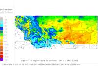
Also try the full-featured calculator/DD model | |
|
| |||||||||||||||||||||||||
|
Montana USA Weather Data, Plant Disease Risk and Degree-Day Models METAR Network - other tables for MT include: All Networks, AGRIMET, CWOP/APRS, COOP, HADS, RAWS, MT_DOT, MSUSPUD, see our homepage. | |||||||||||||||||||||||||
| |||||||||||||||||||||||||
| # | Location linked to hourly weather, plant disease models and forecasts using "Mypest Page" removed due to excessive bot activity |
County |
Re- cent data QA |
Fore- cast based virt data |
Nearby station based virt data |
Station code, links to NWS recent weather |
Links to NWS fore- casts |
Net- work Elev. (ft) |
Lat./ Long. (Dec. Deg.) |
Max-min temperature data and degree-days (click radio button to calc.) |
10 yr avgs |
30 yr avgs |
nmme fcast |
cfs fcast |
||||||||||
|---|---|---|---|---|---|---|---|---|---|---|---|---|---|---|---|---|---|---|---|---|---|---|---|---|
| 1 | Kilo Harlowton | Wheatland Co |
|
na na |
na na |
|
|
4452 | 46.50000 -109.80000 |
2021
|
nmme | cfs | ||||||||||||
| 2 | Baker Muni Apt | Fallon |
|
na na |
na na |
|
|
2969 | 46.34778 -104.25722 |
2021
|
2020
|
2019
|
2018
|
2017
|
2016
|
AVG | AVG | nmme | cfs | |||||
| 3 | Big Horn Co Apt | Rosebud Coun |
|
na na |
na na |
|
|
3025 | 45.74417 -107.66028 |
2021
|
nmme | cfs | ||||||||||||
| 4 | Big Timber Airport | Sweet Grass |
|
na na |
na na |
|
|
4492 | 45.80639 -109.98083 |
2021
|
2020
|
2019
|
2018
|
AVG | AVG | nmme | cfs | |||||||
| 5 | Billings Logan Int Apt | Yellowstone |
|
na na |
na na |
|
|
3648 | 45.80667 -108.54194 |
2021
|
2020
|
2019
|
2018
|
2017
|
2016
|
AVG | AVG | nmme | cfs | |||||
| 6 | Bozeman Gallatin Fld | Gallatin |
|
na na |
na na |
|
|
4475 | 45.78806 -111.16056 |
2021
|
2020
|
2019
|
2018
|
2017
|
2016
|
AVG | AVG | nmme | cfs | |||||
| 7 | Butte Bert Mooney Apt | Jefferson |
|
na na |
na na |
|
|
5545 | 45.95444 -112.49750 |
2021
|
2020
|
2019
|
2018
|
2017
|
2016
|
AVG | AVG | nmme | cfs | |||||
| 8 | Chinook | Blaine Count |
|
na na |
na na |
|
|
2416 | 48.58889 -109.25000 |
2021
|
2020
|
2019
|
2018
|
AVG | AVG | nmme | cfs | |||||||
| 9 | Cut Bank Muni Apt | Glacier |
|
na na |
na na |
|
|
3855 | 48.60806 -112.37583 |
2021
|
2020
|
2019
|
2018
|
2017
|
2016
|
AVG | AVG | nmme | cfs | |||||
| 10 | Delta | Fergus Count |
|
na na |
na na |
|
|
3587 | 47.38000 -109.81972 |
2021
|
nmme | cfs | ||||||||||||
| 11 | Dillon Airport | Beaverhead |
|
na na |
na na |
|
|
5239 | 45.25750 -112.55417 |
2021
|
2020
|
2019
|
2018
|
2017
|
2016
|
AVG | AVG | nmme | cfs | |||||
| 12 | Echo | Fergus Count |
|
na na |
na na |
|
|
3661 | 47.45333 -109.41611 |
2021
|
2020
|
2019
|
2018
|
2017
|
2016
|
nmme | cfs | |||||||
| 13 | ENNIS BIG SKY | Gallatin |
|
na na |
na na |
|
|
5383 | 45.27167 -111.64833 |
2021
|
2020
|
2019
|
2018
|
AVG | AVG | nmme | cfs | |||||||
| 14 | Forsyth | Rosebud Coun |
|
na na |
na na |
|
|
2727 | 46.27083 -106.62389 |
2021
|
2020
|
2019
|
2018
|
AVG | AVG | nmme | cfs | |||||||
| 15 | Foxtrot | Teton County |
|
na na |
na na |
|
|
4373 | 47.60000 -112.30000 |
2021
|
nmme | cfs | ||||||||||||
| 16 | Geyser | Judith Basin |
|
na na |
na na |
|
|
3957 | 47.30000 -110.40000 | nmme | ||||||||||||||
| 17 | Kalispell Glacier Prk | Flathead |
|
na na |
na na |
|
|
2972 | 48.30417 -114.26333 |
2021
|
2020
|
2019
|
2018
|
2017
|
2016
|
AVG | AVG | nmme | cfs | |||||
| 18 | Glasgow Int Apt | Valley |
|
na na |
na na |
|
|
2293 | 48.21389 -106.62139 |
2021
|
2020
|
2019
|
2018
|
2017
|
2016
|
AVG | AVG | nmme | cfs | |||||
| 19 | Glendive Dawson Commun | Dawson |
|
na na |
na na |
|
|
2457 | 47.13306 -104.80000 |
2021
|
2020
|
2019
|
2018
|
2017
|
2016
|
AVG | AVG | nmme | cfs | |||||
| 20 | Golf | Lewis and Cl |
|
na na |
na na |
|
|
4301 | 47.32972 -112.10000 |
2021
|
nmme | cfs | ||||||||||||
| 21 | Great Fls Int Apt | Chouteau |
|
na na |
na na |
|
|
3675 | 47.47306 -111.38194 |
2021
|
2020
|
2019
|
2018
|
2017
|
2016
|
AVG | AVG | nmme | cfs | |||||
| 22 | Havre CtyCo Apt | Hill |
|
na na |
na na |
|
|
2589 | 48.54278 -109.76306 |
2021
|
2020
|
2019
|
2018
|
2017
|
2016
|
AVG | AVG | nmme | cfs | |||||
| 23 | Helena Reg Apt | Lewis and Cl |
|
na na |
na na |
|
|
3871 | 46.60556 -111.96333 |
2021
|
2020
|
2019
|
2018
|
2017
|
2016
|
AVG | AVG | nmme | cfs | |||||
| 24 | Hotel | Teton County |
|
na na |
na na |
|
|
3868 | 47.69722 -111.94278 | nmme | cfs | |||||||||||||
| 25 | India | Lewis and Cl |
|
na na |
na na |
|
|
3573 | 47.30000 -111.50000 | nmme | ||||||||||||||
| 26 | Jordan Airport | Garfield |
|
na na |
na na |
|
|
2661 | 47.32556 -106.94750 |
2021
|
2020
|
2019
|
2018
|
2017
|
2016
|
AVG | AVG | nmme | cfs | |||||
| 27 | Juliett | Teton County |
|
na na |
na na |
|
|
3779 | 47.75139 -111.54667 |
2021
|
nmme | cfs | ||||||||||||
| 28 | Lewistown Muni Apt | Fergus |
|
na na |
na na |
|
|
4167 | 47.04917 -109.46639 |
2021
|
2020
|
2019
|
2018
|
2017
|
2016
|
AVG | AVG | nmme | cfs | |||||
| 29 | Libby | Lincoln Coun |
|
na na |
na na |
|
|
2601 | 48.28389 -115.48972 |
2021
|
2020
|
2019
|
2018
|
AVG | AVG | nmme | cfs | |||||||
| 30 | Lima Judith Gap | Fergus Count |
|
na na |
na na |
|
|
4744 | 46.70000 -109.70000 | nmme | cfs | |||||||||||||
| 31 | Livingston Miss Fld A | Park |
|
na na |
na na |
|
|
4656 | 45.69917 -110.44806 |
2021
|
2020
|
2019
|
2018
|
2017
|
2016
|
AVG | AVG | nmme | cfs | |||||
| 32 | Malmstrom AFB | Chouteau |
|
na na |
na na |
|
|
3527 | 47.50000 -111.18306 |
2021
|
2020
|
2019
|
2018
|
2017
|
2016
|
AVG | AVG | nmme | cfs | |||||
| 33 | MALTA AIRPORT | Phillips |
|
na na |
na na |
|
|
2254 | 48.36667 -107.91917 |
2021
|
2020
|
2019
|
2018
|
2017
|
2016
|
AVG | AVG | nmme | cfs | |||||
| 34 | Miles Cty Frank Wiley | Custer |
|
na na |
na na |
|
|
2628 | 46.42806 -105.88639 |
2021
|
2020
|
2019
|
2018
|
2017
|
2016
|
AVG | AVG | nmme | cfs | |||||
| 35 | Missoula Int Apt | Missoula |
|
na na |
na na |
|
|
3199 | 46.92056 -114.09250 |
2021
|
2020
|
2019
|
2018
|
2017
|
2016
|
AVG | AVG | nmme | cfs | |||||
| 36 | Moore | Fergus Count |
|
na na |
na na |
|
|
4190 | 47.00000 -109.60000 |
2021
|
nmme | cfs | ||||||||||||
| 37 | N BAR Ranch Airport | Fergus Count |
|
na na |
na na |
|
|
4446 | 46.83806 -108.93667 |
2021
|
2020
|
2019
|
2018
|
2017
|
2016
|
AVG | AVG | nmme | cfs | |||||
| 38 | November | Fergus Count |
|
na na |
na na |
|
|
3822 | 47.10000 -109.00000 |
2021
|
nmme | cfs | ||||||||||||
| 39 | Poplar | Roosevelt Co |
|
na na |
na na |
|
|
2036 | 48.13472 -105.16194 |
2021
|
2020
|
2019
|
2018
|
AVG | AVG | nmme | cfs | |||||||
| 40 | Ravalli County Airport | Ravalli Coun |
|
na na |
na na |
|
|
3644 | 46.25444 -114.12444 |
2021
|
nmme | cfs | ||||||||||||
| 41 | Raynesford | Cascade Coun |
|
na na |
na na |
|
|
4177 | 47.30000 -110.80000 |
2021
|
nmme | cfs | ||||||||||||
| 42 | Roy | Fergus Count |
|
na na |
na na |
|
|
3451 | 47.30000 -108.90000 |
2021
|
nmme | cfs | ||||||||||||
| 43 | Ruby Val Fld Apt | Beaverhead C |
|
na na |
na na |
|
|
4789 | 45.53528 -112.30222 |
2021
|
nmme | cfs | ||||||||||||
| 44 | Shelby Airport | Toole County |
|
na na |
na na |
|
|
3443 | 48.54056 -111.87111 | nmme | cfs | |||||||||||||
| 45 | SidneyRichland | Richland |
|
na na |
na na |
|
|
1985 | 47.70000 -104.20000 |
2021
|
2020
|
2019
|
2018
|
2017
|
2016
|
AVG | AVG | nmme | cfs | |||||
| 46 | West Yellowstone | Gallatin |
|
na na |
na na |
|
|
6644 | 44.68306 -111.11667 |
2021
|
2020
|
2019
|
2018
|
2017
|
2016
|
AVG | AVG | nmme | cfs | |||||
| 47 | Windham | Fergus Count |
|
na na |
na na |
|
|
4446 | 47.10000 -110.20000 | nmme | cfs | |||||||||||||
| 48 | Wolf Pt Clayton Apt | Roosevelt |
|
na na |
na na |
|
|
1985 | 48.09417 -105.57694 |
2021
|
2020
|
2019
|
2018
|
2017
|
2016
|
AVG | AVG | nmme | cfs | |||||
[USPEST.ORG/WEA Home]
[Intro]
[US DD Mapmaker]
[Main Table Index]
[Links]


|